In the previous article, has been described how the potential for changes qibla direction at someplace that caused by the earthquake. Visit this
Link!
The Change of Qibla Direction.
Now, in this article we will describe one example of the shift of coordinates that caused by the earthquake, and the changing direction of qibla. How big is it? And how big is the change?
 |
| Simulation of The Change of Qibla Direction |
One of the mosques we have sampled is the Baiturrahim mosque in Ule Lheue, Aceh, Indonesia. One of the areas that was hit by the Tsunami on December 26, 2004 with a strength 9.3 Mw. The tsunami was the result of an earthquake in the Indian Ocean, which took victims from six countries : Indonesia, India, Sri Lanka, Thailand, the Maldives and Somalia.
 |
Simulation of Tsunami 2004 in Indian Ocean
Source : Wikipedia.com |
Please see some image below, these images we got from Google satellite imagery in Google Earth App, in a few different times.
 |
| Image 1 : The Capture of Baiturrahim 2004 |
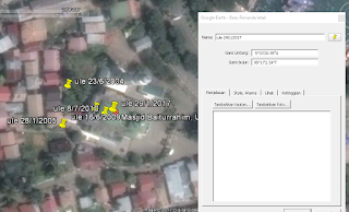
Image 1: Satellite images taken on June 23, 2004, before the earthquake occured. in this figure there is the coordinate value of the roof of the Baiturrahim Mosque is 5˚ 33 '21.4 "N and 95˚ 17' 1.7" E.
 |
| Image 2 : The Capture of Baiturrahim 2005 |
Image 2 : Satellite images on January 28, 2005, images taken several months after the earthquake. the coordinates shifted to 5˚ 33 '20.67 "N and 95˚ 17' 1.61" E. coordinates shifted to the South West.
 |
| Image 3 : The Capture of Baiturrahim 2009 |
Image 3: Satellite image on June 16, 2009, image taken 4 years after the earthquake. The coordinates again shifted towards the North East, the coordinates are 5˚ 33 '20.97 "N and 95˚ 17' 2.22" E
 |
| Image 4 : The Capture of Baiturrahim 2010 |
Image 4: Satellite images on July 8, 2010, shifting South East to 5˚ 33 '20.9 "N and 95˚ 17' 2.39" E
 |
| Image 5 : The Capture of Baiturrahim 2017 |
Image 5 : The last image on January 29, 2017, shifting North East to 5˚ 33 '20.95 "N and 95˚ 17' 2.54" E
 |
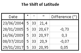
| Latitude Shift's |
 |
| Longitude Shift's |
Of the drawings, the greatest shift occurred between June 23, 2004 and January 28, 2005. where between the dates there was a very large earthquake. The latitude shifts by 0.73 " to the South and longitude shifts by 0.09" to the West.
There was also a substantial shift, between January 28, 2005 and June 16, 2009, after I searched further, there was also some earthquake that occurred between that date, at Nias, Indonesia in 2005 and at West Sumatra, Indonesia in 2007. The latitude shift by 0.3 " to the North and longitude shifts by 0.61" to the East.
For the other date the shift is not too large, is between 0.05 "- 0.17", because there is no earthquake, the shift according to our, occurs caused by the shift of the earth's plate, but not too large, so it didn't cause an earthquake.
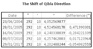
As for the qibla shift, I have calculated the direction of the qibla from some conditions with spherical algorithms calculation, can be seen from the following table:
 |
| Qibla Direction Shift's |
The shifting direction of the qiblah that happened was very small, and almost no effect, less than 0.5". The 0.5" impact was caused by the tsunami that occurred on December 26, 2004. Then the impact of the Nias and West Sumatra earthquakes was less than 0.3", while in other condition, the qibla direction shifted less than 0.2" .
A shift in the direction of qibla is very possible, although the shift is very small, but it should be checked regularly, because if the slight shift is repeated several times it will produce a big shift.
Visit this link for the previous discussion.
The Change of Qibla Direction 1


