The Pole of Earth and The Point of Compass

thumbnail
The Poles
Pole are defined as an axis, the polar division of the earth exists a variety, including the magnetic poles of the earth and the geographical poles of the earth:
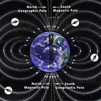
The Poles of the Earth
Source : http://www.calendarinthesky.org
1. Earth's Magnetic Pole
Have you ever had a compass? the compass you have will show you the direction of North, East, South and West. This direction is a magnetic direction. The direction indicated by the compass is the result of the pulling force of the Earth's magnetic poles.
The Earth's magnetic pole is not right at the Earth's axis, the Earth's magnetic pole position is fluid, the North direction is indicated as a magnetic North that is affected by the gravitational pull force of the earth, so it has a different value every day, and every where.

2. Earth's Geography Pole
This pole is the original axis of the earth, its position remains at one point, and does not change. The polar position is at 90 degrees from the Equator (North Pole), and also -90 degrees from the Equator (South Pole). The rotation motion of the earth for approximately 24 hours rotates through this axis.
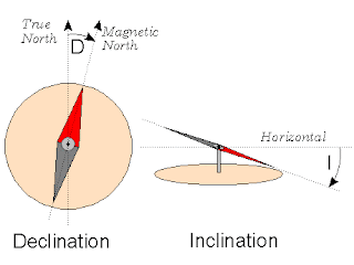
Inclination and Declination of The Compass
Source : http://digilander.libero.it
Compass is a tool that use the magnetic poles of the earth. Although the compass does not show the right direction, it can still be used accurately (leading to Earth's geographical poles) with some corrections, such as declination and inclination.
Magnetic declination is a horizontal shift toward the east or the west. Magnetic Inclination is a vertical shift toward the north or east direction of the compass. The value of this declination changes every day, we can check at Magnetic Declination. Meanwhile, the inclination value varies everywhere, depending on the position of the compass in the latitude. If the compass is in the southern latitudes, then the inclination of the compass will lean towards the south, and vice versa.

Points of The Compass
Source : https://en.wikipedia.org
Point of Compass is a guide to determine direction, usually used in Navigation system. There are 8 principle directions in this point of the compass system. Namely : North, Northeast, East, Southeast, South, Southwest, West, Northwest.
There are several ways to know the true winds, one of them is by using a compass as I mentioned above. Another way is to use the Sun :

1. Shortest shadow
Plug the stick to the ground in a flat position. With this method we are only looking for the shortest shadow when meridian pass/zawal (Sun at the zenith point), then we see the Sun declination value, if the declination of the Northern Sun is positive, so the shadow of the Sun points south direction, if the declination is South or the value is negative, so the shadow of the Sun leads North direction. But this method has a weakness, if the Sun is right above where we are, so there will be no shadow.

2. Shadows before and after Merpass / zawal
Plug the stick to the ground in a flat position, then make 1 to 3 circles around the stick with the stick as the center point. Observe before merpass, and observe the shadow that the end of the line touching the circle lines you have created. And make a point on the tangent. Observe after merpass, and observe the shadow that the end of the line touching the circle lines you have created. And make a point on the allusion. Connect the 2 points. The first point shows the true West direction, the second point shows of the true East direction.

3. Use the azimutal value of the Sun
This method is practically easier, but this method uses calculations. the first way is Shooting the Sun, then Counting the azimut of the Sun and then pointing towards 0 value (True North).

The above ways will be explained in another article.

Calculation of Qibla Direction for Indonesian Places

thumbnail
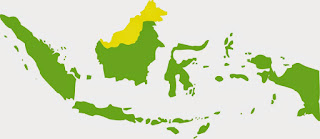
Indonesian Map's
Indonesian Map's
Indonesia is located on the east of the Ka'ba, and is in the south of the Ka'ba, so in logical direction, the direction of the qibla in Indonesia leads to the North West. there are some data that must be searched first to calculate the direction of qibla, that is:

1. Latitude of Ka'ba (φk)
2. Longitude of Ka'ba (λx)
3. Latitude Place (φx)
4. Longitude Place (λx)

For Latitude and Longitude data Ka'ba is usually constant / fixed, but some people vary in its determination, one of the Ka'ba coordinate value ​​used is 21˚ 25 ' 21,01" N and 39˚ 49' 34,33" E. For coordinate data for the place can be searched with various tools, such as GPS. visit this link. Determine Coordinate with GPS.

This calculation uses the assumption that the Earth is a sphere, so this way using the Spherical Algorithm theory. The steps must be taken as follows:

1. Finding the longitude difference (λd) with the formula : λd = (λx - λx).
2. Finding the qibla direction angle (QD) with the formula: Cotan QD = Tan φk * Cos φx / Sin λd - Sin φx / Tan λd.
3. Then finding qibla azimuth value (QA) with the formula: QA = 360 - QD

Average Qibla Azimuth of Indonesia
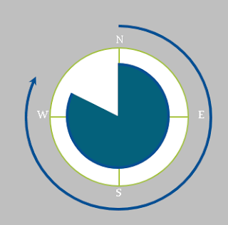
The direction of the Qiblah that we count, measured from the True North clockwise to the value of the azimuth angle. For the example calculations will be discussed at the next session.

The Change of Qibla Direction 2

thumbnail
In the previous article, has been described how the potential for changes qibla direction at someplace that caused by the earthquake. Visit this Link! The Change of Qibla Direction.

Now, in this article we will describe one example of the shift of coordinates that caused by the earthquake, and the changing direction of qibla. How big is it? And how big is the change?

Sample of Qibla Direction Change
Simulation of The Change of Qibla Direction
One of the mosques we have sampled is the Baiturrahim mosque in Ule Lheue, Aceh, Indonesia. One of the areas that was hit by the Tsunami on December 26, 2004 with a strength 9.3 Mw. The tsunami was the result of an earthquake in the Indian Ocean, which took victims from six countries : Indonesia, India, Sri Lanka, Thailand, the Maldives and Somalia.

Tsunami
Simulation of Tsunami 2004 in Indian Ocean
Source : Wikipedia.com
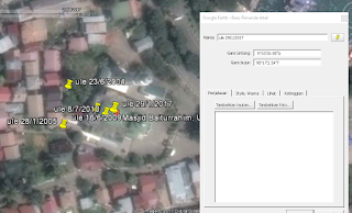
Please see some image below, these images we got from Google satellite imagery in Google Earth App, in a few different times.

The Shift of The Baiturrahim Mosque
Image 1 : The Capture of Baiturrahim 2004
Image 1: Satellite images taken on June 23, 2004, before the earthquake occured. in this figure there is the coordinate value of the roof of the Baiturrahim Mosque is 5˚ 33 '21.4 "N and 95˚ 17' 1.7" E.


The Shift of The Baiturrahim Mosque
Image 2 : The Capture of Baiturrahim 2005

Image 2 : Satellite images on January 28, 2005, images taken several months after the earthquake. the coordinates shifted to 5˚ 33 '20.67 "N and 95˚ 17' 1.61" E. coordinates shifted to the South West.

The Shift of TheMosque
Image 3 : The Capture of Baiturrahim 2009

Image 3: Satellite image on June 16, 2009, image taken 4 years after the earthquake. The coordinates again shifted towards the North East, the coordinates are 5˚ 33 '20.97 "N and 95˚ 17' 2.22" E

The Shift of TheMosque
Image 4 : The Capture of Baiturrahim 2010

Image 4: Satellite images on July 8, 2010, shifting South East to 5˚ 33 '20.9 "N and 95˚ 17' 2.39" E

The Shift of TheMosque
Image 5 : The Capture of Baiturrahim 2017
Image 5 : The last image on January 29, 2017, shifting North East to 5˚ 33 '20.95 "N and 95˚ 17' 2.54" E
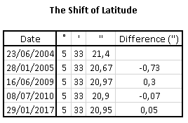
The Shift of The Mosque Latitude
Latitude Shift's
The Shift of The Mosque Longitude
Longitude Shift's
Of the drawings, the greatest shift occurred between June 23, 2004 and January 28, 2005. where between the dates there was a very large earthquake. The latitude shifts by 0.73 " to the South and longitude shifts by 0.09" to the West.

There was also a substantial shift, between January 28, 2005 and June 16, 2009, after I searched further, there was also some earthquake that occurred between that date, at Nias, Indonesia in 2005 and at West Sumatra, Indonesia in 2007. The latitude shift by 0.3 " to the North and longitude shifts by 0.61" to the East.

For the other date the shift is not too large, is between 0.05 "- 0.17", because there is no earthquake, the shift according to our, occurs caused by the shift of the earth's plate, but not too large, so it didn't cause an earthquake.

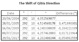
As for the qibla shift, I have calculated the direction of the qibla from some conditions with spherical algorithms calculation, can be seen from the following table:
The Shift of The Mosque qibla
Qibla Direction Shift's
The shifting direction of the qiblah that happened was very small, and almost no effect, less than 0.5". The 0.5" impact was caused by the tsunami that occurred on December 26, 2004. Then the impact of the Nias and West Sumatra earthquakes was less than 0.3", while in other condition, the qibla direction shifted less than 0.2" .

A shift in the direction of qibla is very possible, although the shift is very small, but it should be checked regularly, because if the slight shift is repeated several times it will produce a big shift.

Visit this link for the previous discussion. The Change of Qibla Direction 1

The Change of Qibla Direction

thumbnail
Is it possible to change the direction of qibla ? may be. the direction of qibla still facing the Ka'ba in Mecca, but the direction that will shift. qibla direction may occur, this is caused by a shift in the earth's plate, or earthquake.
The Chage of Qibla Direction caused by earthquake
Source : www.emaze.com
In a study conducted by Yusfania, she explained about the shift location caused by the earthquake that occurred in Sumatra or the Indian Ocean, the study resulted in the conclusion that the earthquake that occurred in the Indian Ocean in April 2012 led to a position shift of 0.3 - 2.4 meters to North East.

This is a fact that we must accept, because if the position of a place changes, it will certainly change the coordinates of the place, and then it will have an impact on the shift in direction of the qiblah at someplace.

Earthquakes are very common, especially in Indonesia. Indonesia is a country with earthquake potential. This happens because the location of Indonesia which is the meeting center of the plates of the Earth, among others, Eurasia, the Philippines, Caroline, Indo-Australia, Pacific and several other minor plates (Hamilton: 1979). In addition, this earthquake is caused by tectonic activity of the plates. Plates it continues to move like the Eurasian and Indo-Australian plates which have an average moving northward, while the Philippine plate movements tend towards the northwest (Hamilton: 1979 in USGS: 2011). Associated with the philipine plate, the Caroline plate has a movement towards the southeast in part of Aru riverbed and towards the northwest in part of Yap riverbed (Seno: 1992 in USGS: 2011).

Therefore, in order to minimize the change of direction of the qibla at someplace, the direction of the qibla should be updated regularly. Because if the shift is collected caused by several earthquakes, then surely the impact will be great.

Renewal of the direction of the qibla should be done by experts, Islamic Astronomer, The Jurist and also Geodesy master. Intensive research should be made to the direction of the qibla at someplace that should also involve the community. So that the public knows about the facts of shifting the direction of qibla caused by a shift of the earth's plate, and for the public to be more careful.

Visit this link for the next discussion. The Change of Qibla Direction 2

Advantages and Disadvantages of Handheld GPS

thumbnail

Advantages and Disadvantages of Handheld GPS

Actually there are many types of GPS, not just handheld / portable GPS, but also GPS Navigation and GPS Smartphone. For the first of these I will discuss in advance about the GPS handheld, and now I will explain the advantages and disadvantages of GPS handheld.
handheld gps
Handheld GPS
GPS handhelds have a high sensitivity in receiving GPS signals and some devices are capable of receiving dual satellite systems from GPS and Glonass. We can also determine the height of place and direction in an area with satellit signal, there are also various additional sensors, for example barometric altimeter and electronic compass so that the determination of height and direction can be done without using satellite signal. This is usually an option in the settings.

The use of barometric altimeter sensors usually must first be done altitude calibration somewhere. We can also use this barometric altimeter to plot air or ambient pressure from time to time, which can help to observe changes in weather conditions.

The advantage of this GPS compass is that it is not influenced by the magnetic field and can guide the direction accurately as it is guided by signals from the satellites (not the buit-in compass sensor). This tool is certainly very helpful when measuring the direction of Qibla.

The area is remote with no phone signal and does not have internet. We recommend choosing a handheld GPS device. Maps are already stored inside, though the images are very standard, such as the appearance of road maps and soil contours, the data maps in the handheld GPS more complete, but usually sold separately (for each country) and the price is quite expensive. Maps do not need to be installed or downloaded. Because portable GPS has been installed one country map when marketed.

GPS handheld is better, more durable, waterproof and suitable for outdoor activities. Users need not be afraid of the natural conditions, because handheld GPS devices or portable GPS are designed for nature activities. Using this GPS we can find the way when through high-sensitivity wilderness, which acquires satellite signals quickly and tracks locations in challenging conditions such as trees and cliffs.

The battery can be replaced because it uses AAA batteries. One portable GPS device can last up to 25 hours. Very suitable for adventure activities in areas far from electrical energy.

But the obstacle, GPS handheld in terms of price is still quite expensive, for a GPS device ranges between Rp. 2,000,000.00 to Rp.10.000.000,00 or about $ 150 USD to $ 750 USD.

The disadvantages of all GPS, including GPS handhelds are GPS will greatly affect the geographical conditions of where we are. GPS will work well if where we are still has a wide sky. The following will be described wherever the GPS will experience a weakness in its use:

1.When someone is in the forest. With the conditions of the trees are so much then the signals that can be received will be a little maybe even no depending on the width of the forest.
2.When someone is in the water or when someone is diving. Do not expect to use this tool when diving.
3. Electronic devices that can emit electromagnetic waves may affect performance degradation rather than GPS.
4. Buildings. Not only when inside the building, being between 2 tall buildings will also cause an effect like being in a valley.
5. Signals that bounce, eg when in between high-rise buildings, can disrupt the calculation of navigation tools so that navigation tools can indicate the wrong position or not accurate.
6. Glass film car, especially metal-containing.