Calculation of Qibla Direction for Indonesian Places

thumbnail
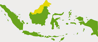
Indonesian Map's
Indonesian Map's
Indonesia is located on the east of the Ka'ba, and is in the south of the Ka'ba, so in logical direction, the direction of the qibla in Indonesia leads to the North West. there are some data that must be searched first to calculate the direction of qibla, that is:

1. Latitude of Ka'ba (φk)
2. Longitude of Ka'ba (λx)
3. Latitude Place (φx)
4. Longitude Place (λx)

For Latitude and Longitude data Ka'ba is usually constant / fixed, but some people vary in its determination, one of the Ka'ba coordinate value ​​used is 21˚ 25 ' 21,01" N and 39˚ 49' 34,33" E. For coordinate data for the place can be searched with various tools, such as GPS. visit this link. Determine Coordinate with GPS.

This calculation uses the assumption that the Earth is a sphere, so this way using the Spherical Algorithm theory. The steps must be taken as follows:

1. Finding the longitude difference (λd) with the formula : λd = (λx - λx).
2. Finding the qibla direction angle (QD) with the formula: Cotan QD = Tan φk * Cos φx / Sin λd - Sin φx / Tan λd.
3. Then finding qibla azimuth value (QA) with the formula: QA = 360 - QD

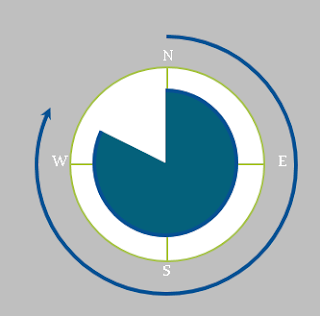
Average Qibla Azimuth of Indonesia
The direction of the Qiblah that we count, measured from the True North clockwise to the value of the azimuth angle. For the example calculations will be discussed at the next session.

Determine The Direction of Qibla with Google Earth

thumbnail

What's interesting about Google Earth? Of course a lot. For the layman, Google Earth is often used to look at photos of his house, or hometown through space. Of course it's nice to see his hometown clearly visible through Google Earth. Everyone in the world will be able to see it. But not the least disappointed, his hometown was not visible at all, whether it is covered by cloud or satellite has not updated the image.

But different from the astronomers. Google Earth is also usually used by them. The ability of Google Earth to identify the surface of the Earth and define it with the value of latitude and longitude make Google Earth useful as a pointer coordinate of a place and determining the direction of Qibla in some places.

How to find the coordinates and direction of Qibla?, Let's see the following explanation! Previously downloaded Google Earth software first! visit this link! Download.

Looking for coordinates somewhere.
1. Go to Google Earth
2. Search the city name in the search field
3. Move the pointer or mouse to where to look for the coordinates
4. See the coordinate values ​​at the bottom of the screen

Examples of searching for the coordinates of Istiqlal Mosque, Jakarta, Indonesia and Ka'ba, Mecca, Saudi Arabia:

coordinate istiqlal in google earth
Coordinate of Istiqlal, Jakarta, Indonesia

coordinate ka'ba in google earth
Coordinate of Ka'ba, Mecca, Saudi Arabia.

Looking for a Qibla direction somewhere
1. Open Google Earth
2. Find the place to search for the direction of the Qibla, also look for the Ka'ba.
3. Move to place area (place to search direction of Qibla)
4. Press the "ruler" button
determine qibla direction with google earth

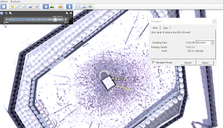
5. Click on the area of ​​the mosque and drag the line to the ka'ba
determine qibla direction with google earth

determine qibla direction with google earth

6. Move to the place area again
determine qibla direction with google earth

7. see the results, we can also see the value of the azimuth Qibla in the column.

Good luck!

Google Qibla Finder

thumbnail
One of the requirements of a valid prayer is facing the Qibla, which is a Ka'ba in Mecca, Saudi Arabia.

To determine the direction of qibla there are many ways, ranging from traditional to modern. Some use a very traditional tool like a stick, some use simple tools but still have a fairly high accuracy such as Mizwala and Istiwaaini, some also use modern tools as well as Teodholite and Total Station. Use of some of these ways may still cause difficulties if who will determine is a beginner.

Nowadays has come a very useful technology for all human activity, that is smartphone. These benefits also apply to the determination of Qibla direction. Lots of users or developers who already take advantage of this technology, a lot of software / program direction of the Qibla is made for smartphones, let alone android smartphone. There are currently around 500 to 600 Qibla direction apps in the playstore, but if we are going to download the app it will be a bit complicated and confused, especially as the accuracy of the apps itself is untested.

But Google has responded to that, Google has presented a web-based qibla direction program that is highly compatible with smartphones especially android and has a very nice interface. The program is called Google Qibla Finder.

To use it we just need to open the browser, any browser through our smarphone, then slide to the site Google Qibla Finder then we will be taken to the Google Qibla Finder page.


Then please note that the GPS position must be in a state of luminous, so that our android can read the coordinates of where we are. In the next step we will choose the interface language we want, then press the Let's Go!


Then Google Qibla Finder will directly calculate, measure the direction of Qibla and apply it to a map which is the location where we are.


If we flip smartphone towards the front, then the interface will turn into a camera and the line appears which is the direction of our place qibla. We can directly mark the direction of Qiblah on our floor through the line that is in our smartphone camera.

Very practical without having to calculate and bring a tool to measure the direction of Qibla. Can we use wherever we are.

Note: There are some things to watch out for, smarphone must support multiple sensors, such as gps, compass and motion sensors, other than that the camera conditions must also be in normal. For the last step I can not exemplify because my camera is in error.

Good luck!

Spherical Earth Coordinate System

thumbnail

Coordinate is a number used to denote a point or a value. Have you ever heard of the term Cartesian Coordinates? A coordinate indicated by the x-axis and the y-axis. With this cartesian coordinate we can see that the area above the x-axis is positive, and the area below the x-axis is negative. While the area to the right of the y-axis is positive and the area to the left of the y-axis is negative.


The spherical coordinate system is also like cartesian coordinates, but the plane in cartesian coordinates is replaced by the spherical. The x-axis in the coordinate of the globe that is the equator (the line that divides the earth into two parts, north and south), and the y-axis in the form of Greenwich line (line connecting the two poles, the north pole and the south pole. This line are in Greenwich London Britaria Kingdom).

Spherical coordinates of the earth consists of two elements namely latitude and longitude. Latitude is an arc or line parallel to the center line of the earth / equator line. The value of the latitude is calculated from the equator line as the 0 point, the positive value for the north and the negative for the south.


Longitude is an arc or line connecting two poles. The value of longitude is calculated from Greenwich as 0 point, the east area of Greenwich is positive and the west area of Greenwich is negative.


Latitude is denoted by phi (φ), the value of latitude ranges from 0 degrees to +90 degrees and 0 degrees to -90 degrees. Longitude is represented by lambda (λ). The values ​​of longitude range from 0 degrees to +179.99 degrees and 0 degrees to -179.99 degrees. For longitude 180 can be positive and negative.


Suppose we will define the position Ka'ba in the form of coordinates (we can get help through the application Google Map / Google Earth). Then the value of Ka'ba coordinate is worth + 21˚ 25 '21,04 "and + 39˚ 49' 34,33" because the position of the Ka'ba is in north latitude and east longitude, it can also be written 21˚ 25 '21,04 " N (North) and 39˚ 49' 34.33 " E (East).