The Pole of Earth and The Point of Compass

thumbnail
The Poles
Pole are defined as an axis, the polar division of the earth exists a variety, including the magnetic poles of the earth and the geographical poles of the earth:
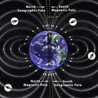
The Poles of the Earth
Source : http://www.calendarinthesky.org
1. Earth's Magnetic Pole
Have you ever had a compass? the compass you have will show you the direction of North, East, South and West. This direction is a magnetic direction. The direction indicated by the compass is the result of the pulling force of the Earth's magnetic poles.
The Earth's magnetic pole is not right at the Earth's axis, the Earth's magnetic pole position is fluid, the North direction is indicated as a magnetic North that is affected by the gravitational pull force of the earth, so it has a different value every day, and every where.

2. Earth's Geography Pole
This pole is the original axis of the earth, its position remains at one point, and does not change. The polar position is at 90 degrees from the Equator (North Pole), and also -90 degrees from the Equator (South Pole). The rotation motion of the earth for approximately 24 hours rotates through this axis.
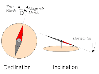
Inclination and Declination of The Compass
Source : http://digilander.libero.it
Compass is a tool that use the magnetic poles of the earth. Although the compass does not show the right direction, it can still be used accurately (leading to Earth's geographical poles) with some corrections, such as declination and inclination.
Magnetic declination is a horizontal shift toward the east or the west. Magnetic Inclination is a vertical shift toward the north or east direction of the compass. The value of this declination changes every day, we can check at Magnetic Declination. Meanwhile, the inclination value varies everywhere, depending on the position of the compass in the latitude. If the compass is in the southern latitudes, then the inclination of the compass will lean towards the south, and vice versa.

Points of The Compass
Source : https://en.wikipedia.org
Point of Compass is a guide to determine direction, usually used in Navigation system. There are 8 principle directions in this point of the compass system. Namely : North, Northeast, East, Southeast, South, Southwest, West, Northwest.
There are several ways to know the true winds, one of them is by using a compass as I mentioned above. Another way is to use the Sun :

1. Shortest shadow
Plug the stick to the ground in a flat position. With this method we are only looking for the shortest shadow when meridian pass/zawal (Sun at the zenith point), then we see the Sun declination value, if the declination of the Northern Sun is positive, so the shadow of the Sun points south direction, if the declination is South or the value is negative, so the shadow of the Sun leads North direction. But this method has a weakness, if the Sun is right above where we are, so there will be no shadow.

2. Shadows before and after Merpass / zawal
Plug the stick to the ground in a flat position, then make 1 to 3 circles around the stick with the stick as the center point. Observe before merpass, and observe the shadow that the end of the line touching the circle lines you have created. And make a point on the tangent. Observe after merpass, and observe the shadow that the end of the line touching the circle lines you have created. And make a point on the allusion. Connect the 2 points. The first point shows the true West direction, the second point shows of the true East direction.

3. Use the azimutal value of the Sun
This method is practically easier, but this method uses calculations. the first way is Shooting the Sun, then Counting the azimut of the Sun and then pointing towards 0 value (True North).

The above ways will be explained in another article.

Determine The Direction of Qibla with Google Earth

thumbnail

What's interesting about Google Earth? Of course a lot. For the layman, Google Earth is often used to look at photos of his house, or hometown through space. Of course it's nice to see his hometown clearly visible through Google Earth. Everyone in the world will be able to see it. But not the least disappointed, his hometown was not visible at all, whether it is covered by cloud or satellite has not updated the image.

But different from the astronomers. Google Earth is also usually used by them. The ability of Google Earth to identify the surface of the Earth and define it with the value of latitude and longitude make Google Earth useful as a pointer coordinate of a place and determining the direction of Qibla in some places.

How to find the coordinates and direction of Qibla?, Let's see the following explanation! Previously downloaded Google Earth software first! visit this link! Download.

Looking for coordinates somewhere.
1. Go to Google Earth
2. Search the city name in the search field
3. Move the pointer or mouse to where to look for the coordinates
4. See the coordinate values ​​at the bottom of the screen

Examples of searching for the coordinates of Istiqlal Mosque, Jakarta, Indonesia and Ka'ba, Mecca, Saudi Arabia:

coordinate istiqlal in google earth
Coordinate of Istiqlal, Jakarta, Indonesia

coordinate ka'ba in google earth
Coordinate of Ka'ba, Mecca, Saudi Arabia.

Looking for a Qibla direction somewhere
1. Open Google Earth
2. Find the place to search for the direction of the Qibla, also look for the Ka'ba.
3. Move to place area (place to search direction of Qibla)
4. Press the "ruler" button
determine qibla direction with google earth

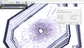
5. Click on the area of ​​the mosque and drag the line to the ka'ba
determine qibla direction with google earth

determine qibla direction with google earth

6. Move to the place area again
determine qibla direction with google earth

7. see the results, we can also see the value of the azimuth Qibla in the column.

Good luck!

Rules facing to The Qiblah

thumbnail
kakbah the qibla of moslem
Source : Google Earth Software

Understanding of the direction of Qiblah is very simple, because the problem of the direction of Qibla is only a directional problem, is the direction of the Ka'ba which is in Mecca and each place must have different direction in facing Qibla.

In simple terms it can be seen that the area in the South Kabah facing to the North, the area located in the North Kabah facing to the South, the area in the East Kabah facing to the West, the area in the West Kabah facing East,

If further clarified then the area located in the North East Kabah facing to the South West, the area located in the South East of the Kabah facing to the North West, the area located in the South West Kabah facing the North East and the area located in the North West Kabah facing South East.

It can be a bit complicated if we further see that the earth is round, then there must be a special calculation for it, but if in a state of urgency can use the logic above.

The meaning of Qiblah in language is derived from the word قبل- يقبل - قبلة, which means facing, whereas in term, the islamic astronomers define with the Direction closest to the Ka'ba, The direction in which Muslims confront their faces during the prayer.

So why should we face qibla ???

The scientist of the fiqh agree that facing the Qiblah in the prayer is a requirement of the validity of the prayer, as the syar'I proposition exists:

Allah has commanded this three times, namely in Al-Baqarah: 144,149 and 150:
قد نرى تقلب وجهك في السماء فلنولينك قبلة ترضاها فول وجهك شطر المسجد الحرام وحيث ما كنتم فولوا وجوهكم شطره وإن الذين أوتوا الكتاب ليعلمون أنه الحق من ربهم وما الله بغافل عما يعملون

and in the hadith :
 قال أبو هريرة رضي الله عنه: قال رسول الله صلى الله عليه وسلم: اذا قمت الي الصلاة فاسبغ الوضوء ثم استقبل القبلة وكبر. رواه   البخارى ومسلم

For people around the holy mosque overlooking the Ka'ba is not a problem because they easily do that. Then what about the people who are far away with the Grand Mosque even outside the city of Mecca. Are we still required to face the true Ka'ba? Or just with an estimate only?

The opinion of the scholars:

Imam As Syafi'i & Shi'a Imamiyah:
Obligatory to the Ka'ba itself, both for the near and far.
If you can know the direction of the Ka'ba itself (exact), then it must face in that direction. If not, then just with an estimate only. (az-Zuhaily, Tafsir Al-Munir, p. 234)

Imam Hambali, Maliki, Hanafi & some scholars of Shi'a Imamiyah:
The direction of qibla is the direction in which the Ka'ba is located, not the Ka'ba itself. (As Suyuthiy, Al Asybah Wa An Nazair, p. 116)

The clerical agreement
All scholars agree that the Ka'ba is a qibla for those who are close and can see it. But they differ on the qibla for the distant and can not see it. (as-Sya'rani, Al-Miizaan Al-Kubra p. 116)

Based on the strongness of prejudice, there are 3 methods in determining the direction of Qibla
1. Overlooking Qibla Sure
A person who is inside the Grand Mosque (Masjidil Haram) and sees the Ka'ba directly, must face himself to Qibla with confidence. This is also referred to as "Ain al-Ka'ba".

2. Overlooking Qibla Estimates
Someone who is outside the Grand Mosque so that they can not see the Ka'ba building, they are obliged to face the Grand Mosque as the intent of facing Qibla in a dzan or approximation is called "Jihat al-Ka'ba"

3. Facing Qibla with Ijtihad
Ijtihad can be used to determine the direction of Qibla from a place far from the Holy Mosque, such as someone outside the holy land of Mecca or even outside Saudi Arabia, the method used is "Jihat al-Qiblah"

Why should a mathematical approach in determining the direction of Qibla?
As long as there is a more accurate way why choose another less accurate way, In a qaidah ushul fiqh
لا عبرة بالظن البين خطؤه
"The theory or practice that is based on the zan (allegation) that is clearly wrong is not considered"

Google Qibla Finder

thumbnail
One of the requirements of a valid prayer is facing the Qibla, which is a Ka'ba in Mecca, Saudi Arabia.

To determine the direction of qibla there are many ways, ranging from traditional to modern. Some use a very traditional tool like a stick, some use simple tools but still have a fairly high accuracy such as Mizwala and Istiwaaini, some also use modern tools as well as Teodholite and Total Station. Use of some of these ways may still cause difficulties if who will determine is a beginner.

Nowadays has come a very useful technology for all human activity, that is smartphone. These benefits also apply to the determination of Qibla direction. Lots of users or developers who already take advantage of this technology, a lot of software / program direction of the Qibla is made for smartphones, let alone android smartphone. There are currently around 500 to 600 Qibla direction apps in the playstore, but if we are going to download the app it will be a bit complicated and confused, especially as the accuracy of the apps itself is untested.

But Google has responded to that, Google has presented a web-based qibla direction program that is highly compatible with smartphones especially android and has a very nice interface. The program is called Google Qibla Finder.

To use it we just need to open the browser, any browser through our smarphone, then slide to the site Google Qibla Finder then we will be taken to the Google Qibla Finder page.


Then please note that the GPS position must be in a state of luminous, so that our android can read the coordinates of where we are. In the next step we will choose the interface language we want, then press the Let's Go!


Then Google Qibla Finder will directly calculate, measure the direction of Qibla and apply it to a map which is the location where we are.


If we flip smartphone towards the front, then the interface will turn into a camera and the line appears which is the direction of our place qibla. We can directly mark the direction of Qiblah on our floor through the line that is in our smartphone camera.

Very practical without having to calculate and bring a tool to measure the direction of Qibla. Can we use wherever we are.

Note: There are some things to watch out for, smarphone must support multiple sensors, such as gps, compass and motion sensors, other than that the camera conditions must also be in normal. For the last step I can not exemplify because my camera is in error.

Good luck!

Spherical Earth Coordinate System

thumbnail

Coordinate is a number used to denote a point or a value. Have you ever heard of the term Cartesian Coordinates? A coordinate indicated by the x-axis and the y-axis. With this cartesian coordinate we can see that the area above the x-axis is positive, and the area below the x-axis is negative. While the area to the right of the y-axis is positive and the area to the left of the y-axis is negative.


The spherical coordinate system is also like cartesian coordinates, but the plane in cartesian coordinates is replaced by the spherical. The x-axis in the coordinate of the globe that is the equator (the line that divides the earth into two parts, north and south), and the y-axis in the form of Greenwich line (line connecting the two poles, the north pole and the south pole. This line are in Greenwich London Britaria Kingdom).

Spherical coordinates of the earth consists of two elements namely latitude and longitude. Latitude is an arc or line parallel to the center line of the earth / equator line. The value of the latitude is calculated from the equator line as the 0 point, the positive value for the north and the negative for the south.


Longitude is an arc or line connecting two poles. The value of longitude is calculated from Greenwich as 0 point, the east area of Greenwich is positive and the west area of Greenwich is negative.


Latitude is denoted by phi (φ), the value of latitude ranges from 0 degrees to +90 degrees and 0 degrees to -90 degrees. Longitude is represented by lambda (λ). The values ​​of longitude range from 0 degrees to +179.99 degrees and 0 degrees to -179.99 degrees. For longitude 180 can be positive and negative.


Suppose we will define the position Ka'ba in the form of coordinates (we can get help through the application Google Map / Google Earth). Then the value of Ka'ba coordinate is worth + 21˚ 25 '21,04 "and + 39˚ 49' 34,33" because the position of the Ka'ba is in north latitude and east longitude, it can also be written 21˚ 25 '21,04 " N (North) and 39˚ 49' 34.33 " E (East).

Introduction to Islamic astronomy (Falak)

thumbnail
Falak (Orbit)
Source : bbc.co.uk
The definition of Islamic astronom (Falak) according to language means orbit, whereas according to the term, Falak is a science, the science that discusses the astronomical conditions of celestial bodies associated with Islamic Shari'a. There are 4 scopes in the study of Islamic astronomy :

1. Qibla direction = discuss the Islamic Shari'a on liability facing the Qiblah while praying, even when not only praying but also when slaughtering sacrificial animals and when burying. To know the direction of the Qiblah can be traced with the science of Islamic astronomy in the discussion of the various directions on the surface of Earth that is experienced from geodesy science. visit this link to know what the Rules of Facing The Qibla.

2. Time of Salat = discusses the obligation to perform the prayers in due time. To know the time of prayer is also required Islamic astronomy science that is experienced from the science of the spherical trigonometry  in the discussion of the daily movement of the Sun's pseudo Earth, visit this link to know what the Prayer Times Marker.

3. The first lunar month = this discussion started from the obligation to perform fasting during Ramadan, when will Ramadan come ?, in this case we can know with Islamic astronomy that discusses the Crescent Moon Phase on the surface of the Earth, The phase is influenced by the circulation of the Earth against Sun, because the light of the Moon comes from the Sun, so the Moon as the Earth's natural satellite reflects light from the sun that directly fell to Earth.

4. Eclipse = this discussion also started from the Islamic Shari'a regarding the extinction in praying during the eclipse, when will the eclipse happen ?. In this case we can also know when the eclipse occurred with Islamic astronomy that discusses the phase of conjunction and opposition of the Sun, Earth, Moon in a straight line.

Islamic astronomy is not as difficult as it is in our minds. Islamic astronomy is fun! It has become one of the most rare sciences of today. Indeed seen by the eyes of astronomy more advanced knowledge, but it is a modern astronomy. Not Islamic astronomy. Rarely anyone learns this science, when in fact this science is very important because it is needed in the religion of Islam.

Partial Lunar Eclipse August 2017

thumbnail
World is enlivened with a total solar eclipse that will occur in the United States on 21 August 2017. It's in America, but in Indonesia there are other events that are not less interesting that partial lunar eclipse. The astronomical event will occur 7-8 August 2017.

Partial lunar eclipses occur when the earth moves between the moon and the sun but not exactly straight in a line. When a partial eclipse occurs, a small part of the moon's surface is covered by the darkest part of the earth's core shadow or the so-called umbra. The remainder of the moon's surface is covered by the outer shadow of the earth or the so-called penumbra.

Launch Time and Date, partial lunar eclipses will occur when two astronomical events occur simultaneously. The event will occur when the moon is in full or full moon. When the earth moves between the moon and the sun but not exactly straight in one line occurs simultaneously.

However, not every full-moon partial eclipse can happen. This happens because the moon moves around the earth with a slope of orbit about 5 degrees to the Earth's orbit and the sun (ecliptic). Because of the moon's orbital tilt, not every new moon phase and full moon, the moon is exactly parallel to the earth and the sun.

Eclipses can only happen near the node point. The natural phenomenon occurs when a full moon occurs near a node, and a solar eclipse occurs when a new moon occurs near a node.

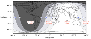
Information of Partial Lunar Eclipse August 2017
Source: eclipse.gsfc.nasa.gov/LEplot/LEplot2001/LE2017Aug07P.pdf

The partial lunar eclipse from 7-8 August 2017 will take place at 22:50 UTC+7 on August 7, 2017 (shown above with P1) as the Moon begins to enter the Earth's penumbral shadow. Then, a small portion of the Moon's face begins to enter the Earth umbra shadow from 00:22 UTC+7 (U1) to 02:18 UTC+7 (U4), its own peak will occur at 01:20 pm (Greatest), ie August 8, 2017.

The lunar eclipse will then end entirely when the Moon leaves the Earth penumbra shadow at 3:50 UTC+7 (P4). That way, the duration of this lunar eclipse reaches 1 hour 55 minutes with the maximum percentage of the peak of the eclipse is 24% disk tergerhanai Moon.

This partial moon eclipse event is quite safe to see with the naked eye with no tools like a binoculars or a telescope. Unlike solar eclipses that require special filtered glasses to protect our eyes from the dangers of the Sun's glare.

This partial lunar eclipse is included in the Saros 119 series and is the 62nd eclipse of a total of 83 eclipses in the series. In this case, the next Saros 119 or 63rd eclipse of the series will occur in about 18 years, precisely on 20 August 2035, which unfortunately is not visible from most parts of Indonesia.

But for partial partial eclipse 7-8 August 2017, Indonesia became one of the best locations to observe it. For those of you who happen to be out of Indonesia during a partial lunar eclipse later, do not worry, this eclipse can also be seen in most of Africa, most of Europe, all of Asia, Australia and Oceania countries.

Information of Partial Lunar Eclipse August 2017
Source: eclipse.gsfc.nasa.gov/LEplot/LEplot2001/LE2017Aug07P.pdf

Learning Astrophotography Techniques at Night

thumbnail


Astrophotography is a branch of astronomy that specializes in the field of photography. 

Astrophotography can also be known as a photography technique to photograph the state of the sky, be it morning, noon, afternoon or evening. 

The state of the sky is always changing every time. If we want to photograph an object in the sky, then we must know in advance how the character of the state of the sky. 

For the night, if we want to photograph the moon with a very bright light like at full moon it is necessary to set low ISO, low shutter speed and also low diaphragm. Make ISO 100, shutter speed about 1/60, and diaphragm (f) 3.5 - 5.

This is different if the month being photographed is a new moon, or commonly known as crescent. Very thin moonlight requires light absorption by a sizable camera. Set ISO 200, shutter speed 5 "- 10", and diaphragm (f) 3.5.

Good luck!


Binoculars

thumbnail
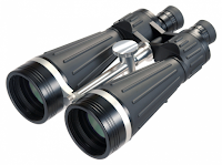
Binoculars are a device that enters the telescope class which means an astronomical device used to magnify the object from a distance, increases the angular size and brightness of the object, but the function of the telescope is actually more in use, not just for the observation of the stars alone , But also used for purposes such as military and shipping. Binoculars of this type is also commonly called "Teropong Medan" (in Indonesia), there are also commonly called "Kiyker". With binoculars objects can be observed stereoscopic (three dimensional)

Binoculars come from the Latin, "bi" meaning two, and "oculus" meaning the eye. As the name implies, this tool has 2 visions / tubes that adjust the amount of our eyes. In it, this binocular has a prism that is used to "fold" the cross-light line so as to produce a shadow in the right direction. With this binocular, the observed objects will be real and will not be reversed.

How binocular lenses work?

Lens Composition

1. Binocular with Erecting Lenses

(Visualization Erecting Lens) 
Source: en.wikipedia.org

This type of binocular can produce zoomed-in / zoom-out as desired, without having to replace eyepiece first. The arrangement for these lenses is Objectif Lens - Erectic Lens - Prism - Eyepiece / Oculer Lens. Erecting Lens position can be shifted, the further position of Erectic Lens from Objectif Lens then the visualization of the observed objects the greater, and vice versa
.
2. Porro Prism Binocular

(Porro Prism Visualization) 
Source: en.wikipedia.org

This type of binoculars has 2 prisms that serve to invert the shadow, the first prism after the objective lens serves to invert the shadow vertically, and the second lens serves to invert the image horizontally. The order is: Objectif Lens - Double Porro Prism - Eyepiece / Oculer Lens.

(Binocular with Porro Prism) 
Source: en.wikipedia.org

This Porro prism produces perfect reflection and refinement. One form of this prism is a 45 ° angled angle, this bracket is used as a double reflector. This prism reverses only one direction using two prisms enforced with each other can be held two-way reversal.

C. Roof Prism Binocular

(Roof Prism Visualization) 
Source: en.wikipedia.org

This type of binoculars has only one prism, and its properties directly invert the shadow horizontally and vertically so that the resulting image is real. This type of binocular physically has a straight appearance because it uses Roof-Prism type prism. The order is: Objective Lens - Roof Prism - Eyepiece / Oculer Lens


(Binocular with Roof Prism) 
Source: en.wikipedia.org

Focuser Position

1. Independent Focus,
Each binocular tube has its own focus regulator. So in the focusing phase just by adjusting the focuser of each binocular tube.

(Binocular with Independent Focus) 
Source: thebinocularshop.com

2. Central focus
Two tubes have only one focuser, but this type of binoculars in one tube usually have a special focuser, this special focuser is required for anisometropic patients

(Binocular with Central Focus) 
Source: 365astronomy.com

Types of Objective Lenses

The outer surface of this objective lens is a protective layer which is usually called a coating. The function of this coating is various, such as anti-reflection, ultra violet filter, light transmition and others. Among the common coatings used in some binoculars are:

1. Red Coating (Ultra Violet Filter)
The red color is dominated for protection in maximum lighting conditions. Binoculars with red coating colors are very well used for daylight in bright light conditions, because they can reduce almost 1/3 light, especially UV light, eg in the desert or hotspot field areas.

2. Blue Coating (Anti Reflection)
The blue color in binocular coating is the most we encounter, blue is the basic coating type, because the standardization of the lens usually must have anti-reflection for each blink of the eye, or reflex light when aiming the target does not make the head become dizzy. Binocular with blue coating is very well used for various conditions, both day and night.

3. Green Coating (Light Transmition)
The green color in the binocular lens is usually a light transmition type of amber stone that is able to drain light on all parts of the image of the captured object lens. Coating type of light transmition is suitable for use in low lighting conditions, eg at dusk or in a dimly lit (not dark without light) so it looks brighter.

4. Multi Coating (Multi Filter)
Not infrequently there are also several other colors, in addition to green, red and blue, such as purple, orange, and others, the color is the result of a combination of multiple coatings combined to benefit from multiple filters.

Types of Mounting

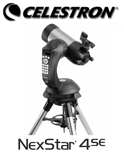
Until now there are no telescope manufacturers that make a special mounting binocular based on semi-automatic (motoric) and automatic (robotic). There is only binocular based hand claps and manual mounting. If you want to use binoculars with automatic mounting or commonly known robotic mounting, can be combined with mounting binoculars with a little modification.

(Modification Celestron Nextar Mount with Orion BT70 Binocular)
Source: id.pinterest.com

Calculation Analysis of Crescent Height Muh. Manshur Al-Batawi in The Book of Sullam Nayyirain

thumbnail
The book of Sulam Nayyirain has an important role in astronomy, its presence being the beginning of the emergence of astronomy science in Indonesia in 1925. The classification of hisab hakīkī bi at-taqrībī for the early month of hisab system in the book does not make it ignored and not studied for students of astronomy , Until now this book still has a "place" for students of astronomy. The al-Manshuriyah group with the calendar of Sulam Nayyirain system is the real proof to the existence of the Nayyirain Embroidery in Indonesia.

KH. Muhammad Manshur al-Battawi is one of the prominent figures in Indonesia of the famous Makkah-Madinah alumni in the thought of astronomy is as it is known that Sulam Nayyirain is one of his fundamental works (Khazin, 2005: 24).

Muhammad Manshur al-Batawi who is a prominent figure as a true teacher by Betawi people both in the religious sciences, especially in astronomy. Noted there are 19 works that have been produced, including: Sulam Nayyirain, Chulashātul Jadwāl, Kaifiyatul Amāl Ijtimā', Khusūf Wal Kusūf, Mizānul I "tidāl, Washilātut Thullāb, Jadwālu Dawāirul Falākiyah, Majmū" u Arba "Rasāil fi Masāilil Hilāl, Jadwāl Farāid, Al-lu "lū Ulmankhum Fi Khulāsoh Mabāhist Sittah Ulmmm, and many other works which essentially deal with the science of astronomy and pharaids (Manshur, 2008: 6).

Guru Manshur (nickname) in his application often uses the Sulam Nayyirain in the early stages of Ramadan, Shawwal and Zulhijah, even to this day the famous al-Manshuriyah calendar whose reckoning uses the reckoning system of Sulam Nayyirain.

Various cases of early determination of the hilal (crescent) in Indonesia, the results of reckoning Sulam Nayyirain often produce higher predictions of hilāl larger than other reckoning systems that are often different, both with the reckoning belonging to the system of hakikī bi at-tahkīkī and contemporary. An example is in the determination of 1 Syawal 1428 H (2007 M). Sulam Nayyirain gives high predictions hilāl = 03 degrees 37 minutes 'and age of hilāl = 14 minutes 28 seconds for Indonesia. This result differs considerably from the calculations of hisab hakīkī bi at-tahkīkī and contemporary.

Guru Manshur in Sulay Nayyirain did not specify the attitude of the hilāl's high criterion which is the minimum limit to be seen visually. He only expounded various scholars' opinions on the high criteria of hilāl, and also mentioned the judge's attitude to be taken when addressing the testimony of a person who claimed to have seen hilāl (Manshur, tt .: 12).

Guru Manshur also mentions in his book that scholars' differing opinions on Hilāl's high criteria without mentioning who the 'ulama' are perusing each of these criteria. He merely deduced that in his opinion Hilāl can be seen as a very relative and conditional boundary. The advice of Guru Manshur in the book of Sulam Nayyirain which he said is about the judge's attitude as a continuation of the criteria of the scholars' mentioned earlier. In this case referring to the government.

Guru Manshur asserted that the judge in determining and drawing the conclusions of the results of rukyah must be on a careful and conscientious attitude. This is due to the difficulty of hilāl to dirukyah and avoid the results of the results of rukyah which indicates errors in merukyah or there lie element of his testimony.
Based on Guru Mansur's thoughts above it can be concluded that in the early determinations of Master Mansur not focusing on rukyatul hilāl, he from the beginning was committed to the concept of ijtimā' qabla al-ghurūb mentioned earlier as the argument on the turn of the hijri month based on hisab in Sulam Nayyirain.
Guru Manshur's statement in his treatise stating that the early adoption system of the hijri month in the book of Sulam Nayyirain was guided by ijtimā'. This is because if ijtimā' occurs when the Sun before it sets then, after the Sun sets is entering the new moon and vice versa, if ijtimā' occurs after the ghurūb is fixed after the Sunset does not enter the new moon (Manshur, tt .: 12).

This opinion is aligned and supported by Hilali's high reckoning system that exists in the book of Sulam Nayyirain. This is due to the Hilāl Sulam Nayyirain's altitude formula = (ghurūb - ijtimā') / 2 or x 30'

The argument of this formula is that on the basis of the Moon leaving the Sun to the east at 12 degrees every day of the night (twenty-four hours) from here it certainly does not seem to be taken into account the daily motion of the Moon and the Sun (Izzuddin 1997: 66).

Hisab crescent height of Sulam Nayyirain based on research resulted that the results of calculations according to the author's statement of the book, that if ijtima' happened qabla al-ghurūb then Hilāl certainly crescent on the horizon. On the contrary, if ijtima' occurs ba'da al-ghurūb hilāl Hilāl can be ascertained by reckoning Sulam Nayyirain, crescent is still under the horizon.

This is because in the recitation of Sulam Nayyirain the time from ijtima' to ghurub divided by 2 or multiplied by 30 minutes with the argument of daily movement of the Moon against Earth of 12 degrees. The simplicity of this reckoning value results in the prediction of Sulam Nayyirain higher than the high-prediction data of modern hilāl astromony, such as Ephemeris.