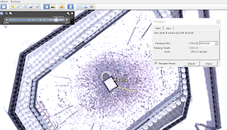
What's interesting about Google Earth? Of course a lot. For the layman, Google Earth is often used to look at photos of his house, or hometown through space. Of course it's nice to see his hometown clearly visible through Google Earth. Everyone in the world will be able to see it. But not the least disappointed, his hometown was not visible at all, whether it is covered by cloud or satellite has not updated the image.
But different from the astronomers. Google Earth is also usually used by them. The ability of Google Earth to identify the surface of the Earth and define it with the value of latitude and longitude make Google Earth useful as a pointer coordinate of a place and determining the direction of Qibla in some places.
How to find the coordinates and direction of Qibla?, Let's see the following explanation! Previously downloaded Google Earth software first! visit this link! Download.
Looking for coordinates somewhere.
1. Go to Google Earth
2. Search the city name in the search field
3. Move the pointer or mouse to where to look for the coordinates
4. See the coordinate values at the bottom of the screen
Examples of searching for the coordinates of Istiqlal Mosque, Jakarta, Indonesia and Ka'ba, Mecca, Saudi Arabia:
Coordinate of Istiqlal, Jakarta, Indonesia
Coordinate of Ka'ba, Mecca, Saudi Arabia.
1. Open Google Earth
2. Find the place to search for the direction of the Qibla, also look for the Ka'ba.
3. Move to place area (place to search direction of Qibla)
6. Move to the place area again
7. see the results, we can also see the value of the azimuth Qibla in the column.
Good luck!


0 comment:
Post a Comment