The Change of Qibla Direction 2

thumbnail
In the previous article, has been described how the potential for changes qibla direction at someplace that caused by the earthquake. Visit this Link! The Change of Qibla Direction.

Now, in this article we will describe one example of the shift of coordinates that caused by the earthquake, and the changing direction of qibla. How big is it? And how big is the change?

Sample of Qibla Direction Change
Simulation of The Change of Qibla Direction
One of the mosques we have sampled is the Baiturrahim mosque in Ule Lheue, Aceh, Indonesia. One of the areas that was hit by the Tsunami on December 26, 2004 with a strength 9.3 Mw. The tsunami was the result of an earthquake in the Indian Ocean, which took victims from six countries : Indonesia, India, Sri Lanka, Thailand, the Maldives and Somalia.

Tsunami
Simulation of Tsunami 2004 in Indian Ocean
Source : Wikipedia.com
Please see some image below, these images we got from Google satellite imagery in Google Earth App, in a few different times.

The Shift of The Baiturrahim Mosque
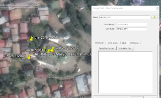
Image 1 : The Capture of Baiturrahim 2004
Image 1: Satellite images taken on June 23, 2004, before the earthquake occured. in this figure there is the coordinate value of the roof of the Baiturrahim Mosque is 5˚ 33 '21.4 "N and 95˚ 17' 1.7" E.


The Shift of The Baiturrahim Mosque
Image 2 : The Capture of Baiturrahim 2005

Image 2 : Satellite images on January 28, 2005, images taken several months after the earthquake. the coordinates shifted to 5˚ 33 '20.67 "N and 95˚ 17' 1.61" E. coordinates shifted to the South West.

The Shift of TheMosque
Image 3 : The Capture of Baiturrahim 2009

Image 3: Satellite image on June 16, 2009, image taken 4 years after the earthquake. The coordinates again shifted towards the North East, the coordinates are 5˚ 33 '20.97 "N and 95˚ 17' 2.22" E

The Shift of TheMosque
Image 4 : The Capture of Baiturrahim 2010

Image 4: Satellite images on July 8, 2010, shifting South East to 5˚ 33 '20.9 "N and 95˚ 17' 2.39" E

The Shift of TheMosque
Image 5 : The Capture of Baiturrahim 2017
Image 5 : The last image on January 29, 2017, shifting North East to 5˚ 33 '20.95 "N and 95˚ 17' 2.54" E
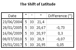
The Shift of The Mosque Latitude
Latitude Shift's
The Shift of The Mosque Longitude
Longitude Shift's
Of the drawings, the greatest shift occurred between June 23, 2004 and January 28, 2005. where between the dates there was a very large earthquake. The latitude shifts by 0.73 " to the South and longitude shifts by 0.09" to the West.

There was also a substantial shift, between January 28, 2005 and June 16, 2009, after I searched further, there was also some earthquake that occurred between that date, at Nias, Indonesia in 2005 and at West Sumatra, Indonesia in 2007. The latitude shift by 0.3 " to the North and longitude shifts by 0.61" to the East.

For the other date the shift is not too large, is between 0.05 "- 0.17", because there is no earthquake, the shift according to our, occurs caused by the shift of the earth's plate, but not too large, so it didn't cause an earthquake.

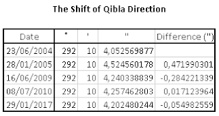
As for the qibla shift, I have calculated the direction of the qibla from some conditions with spherical algorithms calculation, can be seen from the following table:
The Shift of The Mosque qibla
Qibla Direction Shift's
The shifting direction of the qiblah that happened was very small, and almost no effect, less than 0.5". The 0.5" impact was caused by the tsunami that occurred on December 26, 2004. Then the impact of the Nias and West Sumatra earthquakes was less than 0.3", while in other condition, the qibla direction shifted less than 0.2" .

A shift in the direction of qibla is very possible, although the shift is very small, but it should be checked regularly, because if the slight shift is repeated several times it will produce a big shift.

Visit this link for the previous discussion. The Change of Qibla Direction 1

Advantages and Disadvantages of Handheld GPS

thumbnail

Advantages and Disadvantages of Handheld GPS

Actually there are many types of GPS, not just handheld / portable GPS, but also GPS Navigation and GPS Smartphone. For the first of these I will discuss in advance about the GPS handheld, and now I will explain the advantages and disadvantages of GPS handheld.
handheld gps
Handheld GPS
GPS handhelds have a high sensitivity in receiving GPS signals and some devices are capable of receiving dual satellite systems from GPS and Glonass. We can also determine the height of place and direction in an area with satellit signal, there are also various additional sensors, for example barometric altimeter and electronic compass so that the determination of height and direction can be done without using satellite signal. This is usually an option in the settings.

The use of barometric altimeter sensors usually must first be done altitude calibration somewhere. We can also use this barometric altimeter to plot air or ambient pressure from time to time, which can help to observe changes in weather conditions.

The advantage of this GPS compass is that it is not influenced by the magnetic field and can guide the direction accurately as it is guided by signals from the satellites (not the buit-in compass sensor). This tool is certainly very helpful when measuring the direction of Qibla.

The area is remote with no phone signal and does not have internet. We recommend choosing a handheld GPS device. Maps are already stored inside, though the images are very standard, such as the appearance of road maps and soil contours, the data maps in the handheld GPS more complete, but usually sold separately (for each country) and the price is quite expensive. Maps do not need to be installed or downloaded. Because portable GPS has been installed one country map when marketed.

GPS handheld is better, more durable, waterproof and suitable for outdoor activities. Users need not be afraid of the natural conditions, because handheld GPS devices or portable GPS are designed for nature activities. Using this GPS we can find the way when through high-sensitivity wilderness, which acquires satellite signals quickly and tracks locations in challenging conditions such as trees and cliffs.

The battery can be replaced because it uses AAA batteries. One portable GPS device can last up to 25 hours. Very suitable for adventure activities in areas far from electrical energy.

But the obstacle, GPS handheld in terms of price is still quite expensive, for a GPS device ranges between Rp. 2,000,000.00 to Rp.10.000.000,00 or about $ 150 USD to $ 750 USD.

The disadvantages of all GPS, including GPS handhelds are GPS will greatly affect the geographical conditions of where we are. GPS will work well if where we are still has a wide sky. The following will be described wherever the GPS will experience a weakness in its use:

1.When someone is in the forest. With the conditions of the trees are so much then the signals that can be received will be a little maybe even no depending on the width of the forest.
2.When someone is in the water or when someone is diving. Do not expect to use this tool when diving.
3. Electronic devices that can emit electromagnetic waves may affect performance degradation rather than GPS.
4. Buildings. Not only when inside the building, being between 2 tall buildings will also cause an effect like being in a valley.
5. Signals that bounce, eg when in between high-rise buildings, can disrupt the calculation of navigation tools so that navigation tools can indicate the wrong position or not accurate.
6. Glass film car, especially metal-containing.

Menus and Functions on GPS : Garmin 76 C/CSX

thumbnail
I will explain about some menus or functions on the GPS. This time I use GPS Garmin 76 C/CSX. Some GPS devices also have a similar functions.

How to operate Garmin 76 C or 76 CSX?
GPS Garmin 76 C / 76 CSX
1. Key Functions

Inside GPS 76 C there are several buttons that work include to:
A. Power button: Turns the unit on or off. If this button is pressed and released, it can work to adjust the backlight.
B. Zoom In / Out button: To set the size of the scale.
C. Find Button: To go to find menu page and display mob.
D. Quit button: To cancel data entry or close the page.
E. Page or Compass button: To go to the main page and turn the electronic compass off.
F. Menu Button: To enter options, confirm messages or data on-screen. This button can also be used for marking Sign and Waypoint.
G. Rocker Keys: To start moving lists, highlight fields, on-screen buttons, icons, enter data or move to the map section.

2. Getting Satellite Data

For the process of revenue data from satellite, then we must pay attention to the place and condition around. It is advisable to use the GPS in the open and have a wide view. The weather conditions must also be in good condition. For the steps are:
A. Turn on the GPS by pressing the power button. If the GPS has been turned on then it will say "Welcome". The page will quickly face the satellite page.
B. Observe the satellite page and GPS status message when it appears at the top of the page, and soon it will look like a GPSmap. This indicates it will start to search for satellite exploitation status. Not long after that will automatically show our position (latitude and longitude). Visit Determine Coordinate of Place with GPS for more info.

3. Selecting a Page

For all required information or data can be found in four main pages (display screen). These pages include satellites, maps, pointers, and menus. The trick is to press the page button to find the pages.
A. Satellite page: provides a reference for tracked satellites.
B. Page trip computer: provides data and information related to the science of shipping.
C. Page map: provides a view of a map and reference our navigation movement.
D. Page compass: provides guidance for a purpose and direction.
E. Page altimeter: provides path and pressure elevation.
F. Main menu: an existing directory in GPS to specify other settings.

4. Define Waypoint

Waypoint is a marking of places obtained by satellites in a GPS. To mark a place, we can access in the Find Menu by:
A. Press the page button and select the menu page. Press the Up or Down button and select the "Mark" section.
B. Press the enter key. The mark waypoint page will appear with the word "OK?", Hit enter. Waypoint has been stored in GPS memory.

5. Go to the Waypoint Menu
To enter the waypoint we have marked, then we use the Go To facility. How to use it is:
A. Press the page button and select the menu page. Press Up or Down button and select "waypoint". Press Enter. The waypoint page will appear.
B. Press the Up or Down button and select the tab that contains the desired waypoint name and press Enter. The existing waypoint review page will appear.
C. Press Up or Down button to select "GoTo" and press Enter.

6. Exploration on a Waypoint
In the use of the "Go to" facility, we will be directed to follow the directions on the waypoint. The directions provided are N, S, E, W (North, South, East, West). If we cancel, we can use the compass pointing stick to divert the direction toward us. The steps are:
A. Press the page button repeatedly until the compass page is shown. This page contains a bookmark that marks the direction to go.
B. Press the quit button to move to the map page and watch our progress toward the waypoint. The pointer line will show the map and the position arrow movement as we move it.
C. Press the quit button again to move to the travel page. This page provides travel data such as a travel odometer, maximum speed, and more.
D. To stop navigation, press Menu then select stop navigation and then press Enter.

7. Cleaning Track Log
If we have used GPS for multiple trips, then the map view will be full because storing tracks or paths that we have been through. To use this facility the way is:
A. Press the page button and select the menu page.
B. Press Up or Down button and select "Tracks".
C. Press Enter. Use the Up button and select "Clear". Press Enter.

8. Using Map Page 
To use the map page can be done by:
A. Press the page button to go to the main page to the map page.
B. Press the menu button to navigate to the map page selection.
C. Start moving and observing the position arrow on the top of the map. Use the Rocker button to move and move highlights a map item or look into other map areas.

Determine The Coordinates of a Place with GPS.

thumbnail
In the calculation of Islamic Astronomy, the thing that is always required is the coordinates of a place. Many ways and tools can be used to know these coordinates. One of the most famous ways is using GPS (Global Positioning System)

GPS is a navigation and positioning radio system that utilizes satellites as a means of communication. This tool is usually used in vehicle navigation, be it land, sea or air vehicle. Ship and aircraft communication with the station is needed, in order to avoid accidents. GPS is used to know each ship or aircraft position, then reported to the tower / station supervisor at the nearest port or airport.

This GPS will monitor signals from satellites, then GPS will accept the position of the place be it latitude, longitude or altitude place on Earth.

In the Islamic Astronomy, GPS that easy to use is a type of handheld GPS that can be taken anywhere.

GPS has a different level of accuracy, depending on the brand and type of GPS. but overall the tool is quite accurate in determining the coordinates of a place or area.

In this explanation, I will practice using GPS Garmin 72H, but overall, various GPS has a similar way to operate GPS for coordinate determination. The way is :

1. Turn on the GPS in the field, not in the room, around tall buildings, tunnels, and dense forests.

2. Wait a while, about 1-3 minutes, so that GPS receives satellite to make configuration latitude, longitude and altitude data complete.

3. The minimum number of satellites captured to generate coordinates is 4 satellites. And wait a while until the "Location" or "Accuracy" sign shows the smallest number. That sign is the maximum error of the GPS point being, which is predicted by GPS satellite.

4. Then record the coordinates that appear.

determine coordinate with gps
Garmin GPS 72H
Souce : https://www.amazon.com
Example image above, the resulting coordinates are 38 degrees 51,498 minutes North Latitude (N) and 94 degrees 47.838 minutes West Longitude (W).

5. if you want to know the height of the place, press the "page" several times until entering on the page high information place.

Good luck!

ISS Satellite

thumbnail
You must know satellite already? A satellite is an orbiting object on a celestial body, including the Earth. There are two kinds of satellites, natural satellites and artificial satellites. Earth has a natural satellite, one of its functions on Earth is a marker of time for Muslims. While artificial satellites quite a lot, its function is diverse, such as as a means of communication, as weather research, means of transmission of military equipment, and others. More details refer to the following description:

Astronomy Satellite
Used to study planets, stars, and other objects. One example is the Hubble satellite used to photograph the Red Rose Nebula.

Communications Satellite
It is functional for telecommunication, radio, and television purposes using microwave frequencies.

Earth Monitor Satellite (GPS)
Used for navigation and map creation. Radio age conditions that let users know their exact position through the GPS system.

Weather Satellite
Serves to record and submit information about the weather and climate conditions of the Earth. It is a "building" that allows people to live in outer space. This station has been specially designed, so it can be inhabited for several months or even years.

Military Satellite
Is a telegraph satellite or an Earth monitor used for military purposes.

Small Satellites
Small super satellites are flown in space. For example mini-satellites (500-2000kg), micro satellite (10-200kg) and nano satellites (below 10kg).
To be able to operate satellites launched into orbit with the help of rockets. Developed countries such as the United States, Russia, France and Lately China, already have stations to catapult satellites into orbit.

International Space Stasion (ISS)
Source : http://www.infoastronomy.org
ISS (International Space Station) is one of the first satellite launched on November 20, 1998. The launch of ISS is a project of 13 countries, which is used for various functions such as research of various disciplines, Biography, Biotech Geography, Geodesy, Physics, Astronomy, Space Science and others.

ISS has another name "Zarya", designed with a very large size, ISS becomes the largest satellite when compared with other satellites. And has many rooms, including 5 bedrooms, 2 bathrooms and 1 gym, there are also several laboratories specifically designed for research. Many astronauts from various countries who have successfully stop off this ISS satellite, spend many days even for months there, carry out research tasks.

Inside ISS
Inside ISS
Source : http://schools-wikipedia.org

Inside ISS
Inside ISS
Source : http://schools-wikipedia.org

Inside ISS
Inside ISS
Source : http://schools-wikipedia.org
ISS when viewed from the earth has a special and interesting position when compared to other satellites, the ISS can be seen from Earth, because of its large size and has a low orbit about 380 km from Earth, so the orbit of ISS is almost round.

Have you ever been watching the sky, then seeing bright spots like a walking star? Is it a meteor? Is that a plane? It turns out not both, but one of the largest human-made satellites, the International Space Station (ISS).

At certain times, the ISS will be visible in the night sky of your area. ISS will look like a bright star that moves fast over the horizon. ISS is so bright, it can even be seen from downtown though.

Capture ISS with Long Exposure
Source : https://www.universetoday.com
Ever seen ISS? please try it! You can register directly to this Link to get a notification when ISS will pass the sky where you are. Or you can detect through simulation software like stellarium.

Good luck!